World Maps - Professional Satellite Imagery and Vector Maps

|
|
|
WORLD SATELLITE IMAGERY
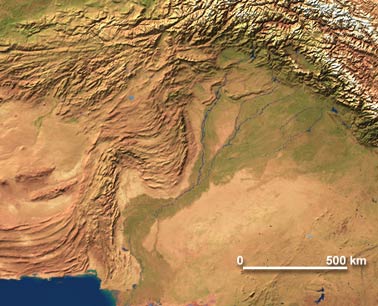
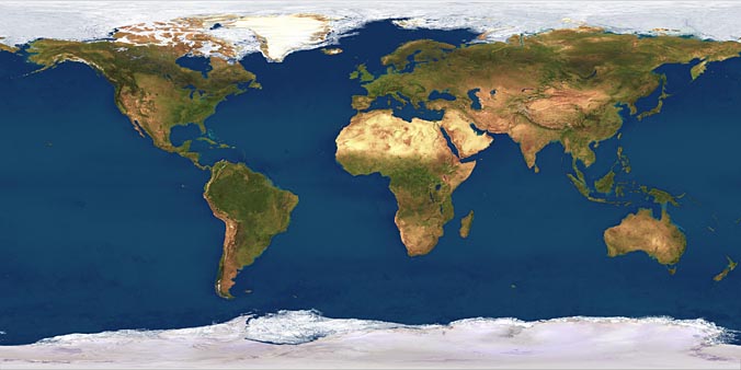
The high-resolution World coverage Satellite Imagemap, with a pixel resolution of 4 km, is 10,800 x 5,400 pixels in overall size - 167 megabytes of data in 24 bit RGB colour. Printed as a poster it would measure 72 x 36 inches at 150 dpi, or 36 x 18 inches at 300 dpi. Also available in 1 km, 2 km, 8 km and 16 km resolution. For 2 km and 4 km resolution the satellite imagery map is supplied with the Illustrator EPS vector map shown below to build a composite world map with geo-political features. The sample image below shows the level of detail in the Straits of Hormuz in the Persian Gulf.
Item 1103: World 1km Satellite Map
Item 1110: World 2km Satellite Map Package Download
Item 1127: World 4km Satellite Map Package Download
|
|
|
|
|
|
|
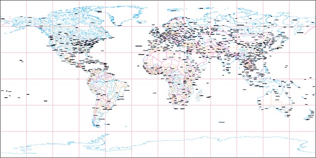
WORLD Illustrator EPS vector map
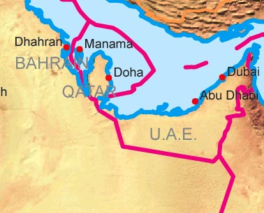
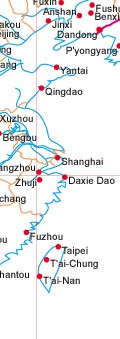
World Map prepared in Illustrator EPS version 9.0 and features nine fully editable and customizable layers. The map has been prepared with a high level of detail and is fully rescalable when opened in Adobe Illustrator and Macromedia FreeHand. The map may be used with the satellite map shown above to build a composite world relief map with overlying geo-political features. Any layer may be selected, edited for color and thickness or removed to build a map view to your specification. The sample image to the right above shows an area of China and Taiwan showing city names, city locations, longitude / latitude grid, international and provincial borders. The sample map (left) shows the level of detail in the Pakistan / Afghanistan area and the sample map (right) below shows the insertion of the satellite image background behind the geopolitical EPS vector map and the level of detail in the Persian Gulf - the two images reflect full view of the background relief texture. Note that Illustrator gives you full control over line color and thickness, text font face, color and size, and options to switch on of off any layer. |
|
|
|
|
|
WORLD ILLUSTRATOR EPS vector map with reduced transparency relief texture
World Map prepared in Illustrator EPS version 9.0 and features nine fully editable and customizable layers and a background texture satellite image map. The vector map bottom layer features the satellite maps shown above to build a composite world map with overlying geo-political features. Any of the Illustrator layers may be selected, edited for color and thickness or removed to build a map view to your specification. In the example below the ocean fill color light blue has been switched on, thereby hiding the deep blue satellite sea color. |
|
|
|
|
Download Options

|
|
|
|
|
|
Satellite map of the world (JPEG) map
|
Satellite map of the world (JPEG)
and Illustrator vector (EPS)
geo-political overlay map package
|
Satellite map of the world (JPEG)
and Illustrator vector (EPS)
geo-political overlay map package
|
|
|
|
|
Return to World Maps Overview |
Digital Wisdom Inc.
USA & Canada orders: 800-800-8560 - International orders: 804-443-9000
Digital Wisdom Inc., Box 11, Tappahannock VA 22560-0011, USA
© Digital Wisdom, Inc.
|